
Daniel’s Levada Directory
Levada do Coronel
Also known as Levada Nova dos Lombardos
Archival documentation — not a current hiking recommendation. Source file on danishome.ch last modified: 2 April 2022
Area
Ponta do Sol/Southwest
Length
3.9 Km
Madrei
-
Madre 1, west side of the Ribeira da Ponta do Sol valley (side stream) N 32°42.600 W 17°05.400 ca. 360 m a.s.l.
-
Madre 2, west side of the Ribeira da Ponta do Sol valley (side stream) N 32°42.100 W 17°05.400 ca. 350 m a.s.l.
Course
At the original cane descent there are traces of the levada continuing north at the same height, until after about 30 metres they ended abruptly at a steep drop down to the gravel track. If you imagine the line continuing from here, about 200 metres further north you come to the Ribeira da Ponta do Sol. To me it is actually clear that the Levada do Coronel originally had its real Madre ('Madre 0') in the Ribeira da Ponta do Sol. The Madre and the first 200 metres were then destroyed again and again by repeated floods (as we also saw vividly in 2014), so another way of taking the water had to be found, whether really at Madre 1 or directly at Madre 2. In the other direction, after the climb, there is a small stream and a wet area that I originally took to be Madre 1: quite neglected, not maintained, and with little water. A few quite exposed spots, at the same height as the Levada do Moinho and a little below the Levada Nova. The levada is not in use on this stretch. A beautiful gallery tunnel in perfect condition, then on, very exposed and overgrown, to Madre 2. From here it is well maintained, but still very exposed at the start.
The levada then swings onto the terraces. Scenic going on to the gallery below Monte, which is extremely exposed and takes some nerve. Shortly after that the path comes up from the valley floor of the Ribeira da Ponta da Sol, then on through terraces and finally to the crossing with the road that climbs from the ER-222 to Lombo de Sao Joao and Covas. After that straight through banana plantations to the crossing with the road to Serrado and Salao. Later a crossing with the road that leads from the ER-222 to Levada do Poiso. Later another crossing with a regional road, and the end in a water tank.
End
Sao Joao ca. 310 m a.s.l.
Function and use
Water supply for the fields around Lombo Sao Joao and Salao
Access
-
To Madre 1 by the stream bed from the Levada Nova or the Levada do Moinho
-
From the car park on the valley floor; the turn-off to it is from the ER-222
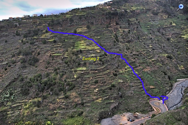
-
From the crossing with the road that climbs from the ER-222 to Lombo de Sao Joao and Covas
-
Crossing with the road to Serrado and Salao
-
Crossing with the road that leads from the ER-222 to Levada do Poiso
-
Crossing with a regional road
Condition
-
Between Madre 1 and Madre 2 the path is not maintained, in places very exposed, and the path has partly slipped away; not without danger
-
From Madre 2 it carries water only in winter and is well maintained; at the end, below Monte, an extremely exposed gallery
Remarks
My guess is that the Levada do Coronel originally had its Madre (Madre 0) in the Ribeira da Ponta do Sol, but that the first part was given up fairly quickly because of repeated flooding, and that it was tapped at Madre 2 in connection with the building of the Levada Nova. Why the path is still so well preserved is unclear; in any case not for visitors, it is too dangerous for that.
A circuit with the Levada do Moinho or the Levada Nova is possible: park on the valley floor at the roundabout, climb the concrete steps, cross the fields to the south-west as far as the levada and on to Madre 1, descend there into the stream bed, go north to the Madre of the Levada do Moinho, back to Lombada and from there down to the car park (sliding and climbing), or a detour by road via Pico do Meiro