Daniel’s Levada Directory
Levada da Rouca
Also known as Levada da Corrida, Levada da Poço da Corrida, Levada da Serra do Estreito de Camara dos Lobos
Archival documentation — not a current hiking recommendation. Source file on danishome.ch last modified: 1 April 2022
Area
Jardim da Serra/Southwest
Length
Eastern branch 1.7 km; western branch originally 6.6 km, now probably about 2.5 km
Year built
1853
Madrei
Eastern branch: Ribeira do Jardim N 32°42.190 W 16°59.380 ca. 1030 m a.s.l. and N 32°42.400 W 16°59.265 ca. 1012 m a.s.l.
Western branch: Ribeira das Eirinhas N 32°42.131 W 16°59.726 ca. 1010 m a.s.l.
Course
Originally the water was taken in the Ribeira do Jardim, in the area of the uppermost houses on the road to the Boca da Corrida, and led into a large collecting basin. Here the levada divided into a western branch (Ramal do Pico da Cruz ou da Rouca) and an eastern branch (Ramal do Jardim da Serra). This distribution was changed at some point.
Today the first part of the Ramal do Pico da Cruz ou da Rouca, from the large collecting basin to the Ribeira das Eirinhas, is dry. Water does still seem to flow now and then, though, because the levada channel is clean and uninterrupted. In the Ribeira das Eirinhas water is taken in, led into a collecting basin, and from there the western branch is fed.
The large collecting basin is also fed by 2 small levadas. One comes from the neighbouring fields straight to the intake in the Ribeira do Jardim and was dry on every one of my visits, but it does still seem to carry water now and then. The other joins the inflow to the large basin about 10 metres downstream from the Madre. Further north it is fed by a pipe whose origin is unclear, and it originally continued north along the road to the Boca da Corrida. That part is no longer active, though, and is partly ruined. The water was probably taken earlier from a side stream of the Ribeira do Jardim. The large collecting basin now serves only to feed the eastern branch.
The
End
Western branch: originally in Nogueira (Estrada do Pomar Novo) ca. 600 m a.s.l., currently possibly before the Estrada do Chote
Eastern branch: Serra Eira da Laje ca. 940 m a.s.l.
Function and use
Water supply for the areas around Achada and Pomar Novo
Access
Access to the Ramal do Pico da Cruz ou da Rouca
-
On the road that leads from Jardim da Serra to the Boca de Corrida (in Corrida a little further north than here, a path goes off to the left straight to the large collecting basin
-
Path from the Estrada da Corrida
-
Path that can be reached from the Estrada do Chote and the Estrada da Corrida
-
Path from the Estrada do Chote
-
Crossing of the Estrada do Chote with the new road from Jardim da Serra to Terreiros and Fontes
-
By the gravel track from the road from Nogueira to Terreiros
-
From the Levada do Norte by the Caminho do Pomar Nova (see the report by the Caminheiros do Barrete de Orelhas)
-
From the end in Nogueira
Access to the Ramal do Jardim da Serra:
-
From the road to the Boca da Corrida
-
By a gravel track from Serra da Eira da Laje
-
Gravel track from Serra da Eira da Laje to the Boca dos Namorados.
Condition
Since the Madres were reorganised, the original Levada da Rouca, with 2 connected branches, has been split into 2 levadas independent of each other.
The Ramal do Pico da Cruz ou da Rouca is fed by a new Madre in the Ribeira das Eirinhas.
A few hundred metres before the Estrada do Chote the water is collected in a water house, and from here the levada is piped; the path continues as a gravel track. Where the levada currently ends is unclear.
The part between the large collecting basin and the new Madre is dry, but easy to walk.
Around Fontainhas I found ruined remains of the levada, which serve as a car graveyard!
One peculiarity worth noting is that the western branch of the levada runs down the middle of a path that a farm vehicle can also drive (see the pictures).
The Ramal do Jardim da Serra is in good condition, with water almost to the end (as of 2016).
Remarks
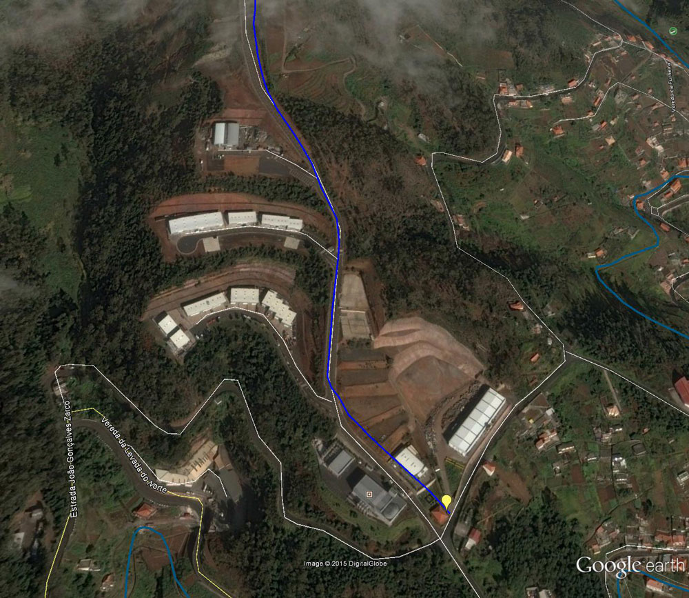
The situation around the end of the levada has changed markedly since the Google Map imagery was taken. Here is a Google Earth picture from 17 January 2015