
Daniel’s Levada Directory
Levada do Norte (south)
Also known as Levada do Norte Sued
Archival documentation — not a current hiking recommendation. Source file on danishome.ch last modified: 21 July 2025
Area
Serra de Agua to Camara dos Lobos/northwest
Length
31,8 km (elevation difference 40 metres! Incredible!!)
Construction period
1953
Madrei
Serra de Agua power station N 32°44.650 W 17°01.100 ca. 580 m a.s.l.
Course
The southern part of the Levada do Norte can be divided into 6 sections:
Section 1: Serra de Agua to the Ribeira do Pico:
Until 1995 a levada with 3 short tunnels and one long one; since 1995 it no longer carries water. Since 1995 the water has been led in 2 separate tunnels to the Ribeira do Pico. The first comes to the surface in the Ribeira do Poço, is led half-open through the stream bed, and that is also where the second tunnel begins. Neither of the present tunnels is accessible!
Right after the Serra de Agua power station it is quite exposed, but on an intact path on the north side of the valley of the Ribeiro do Poço; a path from the VE-4, then a double tunnel with a short open stretch (stream crossing), exposed onwards to a waterfall that crashes straight onto the levada. A bypass of an old destroyed section on a narrow path, passage of a beautiful side branch of the Ribeiro do Poço with scoured pools, over a bridge across the main branch of the Ribeiro do Poço. Directly under the bridge you can see the connecting stretch of the two new tunnels from the Serra de Agua power station to the large stream-training structure in the Ribeiro do Poço. The path goes along the Ribeira do Poco to the old levada bridge at the end of the destroyed section. Right here begins the unpleasant long tunnel (about 1 km). Very wet; in stretches both the levada channel and the path are under water, and you have to balance on the little dividing wall. At the exit a path goes up to the left to a stream-training structure that used to feed the levada with extra water. The levada follows this stream on the east side and then swings into the valley of the Ribeira do Pico. On the right you can make out the Pico do Buzio, whose cockerel-head outline will keep appearing from different viewpoints. From here you also have a fine view of the gallery with the wooden rails, which you pass later in section 2.
A last tunnel, and along a few worked terraces and bee houses to the levada house at the large stream-training structure.
In the large structure the water is held back and separated by a complex system: the greater part flows through the Tunel do Pico Grande into the Curral valley to the Socorridos power station.
A small part flows, as before, into section 2.
See also Walk 2015
Section 2: Ribeira do Pico to Espigao:
The levada first follows the south slope of the Ribeiro do Pico valley. Immediately badly exposed, with no protection; a first challenge is the exposed passage over a piped section. Then comes the passage along a projection, with Madeira's familiar wooden protection, in a gallery cut from the rock. Better not to inspect the protection too closely; it does at least give you something to hold on to.
Then on through more open ground to the next tunnel. After that you are on the rock face above the Ribeira Brava valley. A great view; in this section the levada is partly cut out of a wall. Another 2 tunnels, then the view into the great gorge. The levada path grows narrower and more exposed; at the head of the valley you walk on a little wall about 15 cm wide, with no protection. At least the levada has been well repaired here. Through a tunnel at the head of the valley, and exposed again on the way out of the gorge. Here the path is a little broader. Exposed again above the Ribeira Brava valley, the ground opening out more and more as far as the lombo of Espigao. To the left the path leaves that leads to Espigao (see below).
The section ends with the traverse through the tunnel that passes under Espigao.
See also Walk 2015
Update 2023: It was foreseeable that section 2, between Ribeira do Pico and Espigao, would at some point no longer be maintained.
The effort of maintaining this section eventually became too great, and the water loss was enormous; that something new was being planned here had been known for some time.
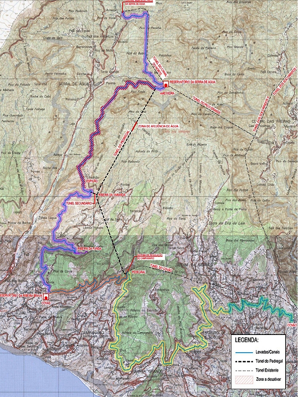
In September 2023 the Tunel do Pedregal was opened.
The tunnel begins after the large stream-training structure in the Ribeira do Pico, where the tunnel into the Curral valley also branches off.
The main channel comes out at Pedragal, near the exit of the Tunel do Covao, onto the old branch of the Levada do Norte.
To keep supplying the area around Eira do Mourao and Boa Morte, there is a side outlet beside the stream crossing of the old Norte over the Ribeira do Espigao.
The section from the Ribeira do Pico to beyond the tunnel under Espigao is therefore no longer maintained, and will presumably never be walkable again.
The plans (pictures below):
Section 3: Espigao tunnel to Eira do Mourao:
First the course in the valley of the Ribeira do Espigao, along a stream-training structure, through a short tunnel that hardly deserves the name. Then on the ridge, with fine views high above the Ribeira Brava valley. The section ends at the crossing with the access road to Eira do Mourao, which goes down-valley from the road to Espigao and Fontes.
See also Walk 2014
Section 4: Eira do Mourao to Boa Morte:
The levada goes a long way east into the cutting of the Ribeira Funda; a branch of the path to the Madre of the Levada do Meio. Changing, fine views over the terraced land. The valley head in the Ribeira Funda, below the road that leads to Espigao. Out of the valley, a path to the active part of the Levada do Meio, later a path to the part of the Levada do Meio that is no longer in use, and on to the Levada do Baixo; through burnt forest south to Boa Morte, where the water is held back and led into large reservoirs (Reservatorio do Sitio das Covas). After that the levada is dry.
See also Walk 2014
Section 5: Boa Morte to Cabo Girao
Dry at first, as far as the Ribeira do Campanario. There a large feeder tunnel, connected to the upper balancing reservoir of the Socorridos power system at Covao. This supplies the levada with water. Fine views high above Campanario, Igreja and many terraces and small villages. Right in the middle of it, the motorway viaduct! Many approaches, and crossings with paths and gravel tracks. The lombo north of Cabo Girao is passed in a tunnel.
Section 6: Cabo Girao to Marinheira:
First high above the terraces of Caldeira. After the crossing with the Estr. Joao Gonzalves Zarco the water is held at a collecting point and led through the Pau Branco tunnel, through the lombo of the same name. The old levada bed can still be followed for a few metres, but it ends in an old landslide cone. You can go on here, but the levada is no longer there. After a short descent and ascent by a silo you meet the levada again, and a little later the tunnel exit.
At the end of the tunnel the water meets the old levada bed again and flows, on the one hand, the "wrong" way towards the water silo at Nogueira and, on the other, on along the normal course. Then a deep cutting into the valley of the Ribeira da Caixa, with two bridge crossings over the side branches of the ribeira and 2 fine masonry passages just before leaving the valley; after that the levada winds through the outer districts of Estreito de Camara de Lobos
See also Walk 2016
At the end in Covao there is a connection to the upper charging chamber of the Socorridos power system. When there is surplus water it is released over a waterfall into the Ribeira dos Soccoridos, which also spills onto the Levada da Faja (see the last picture below).
End
Vargem above Estreito de Camara de Lobos ca. 530 m a.s.l.
Function and use
Irrigation of the areas along the levada from Boa Morte. An essential part of the water supply around Ribeira Brava (feeders from the Ribeira da Ameixieira, springs of Espigao). The terminal branch of the Levada do Norte is also closely tied to the water supply through the Socorridos system
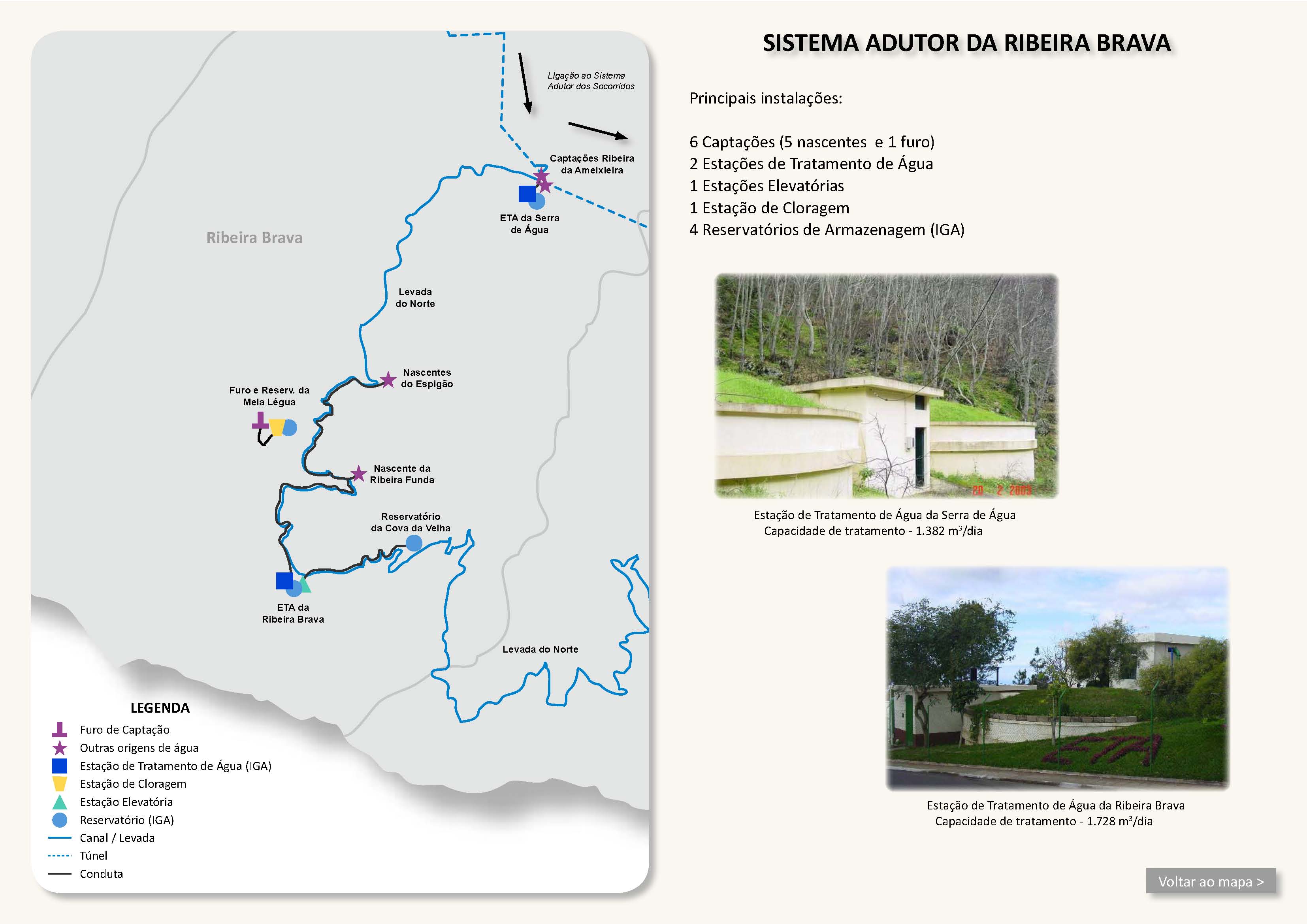
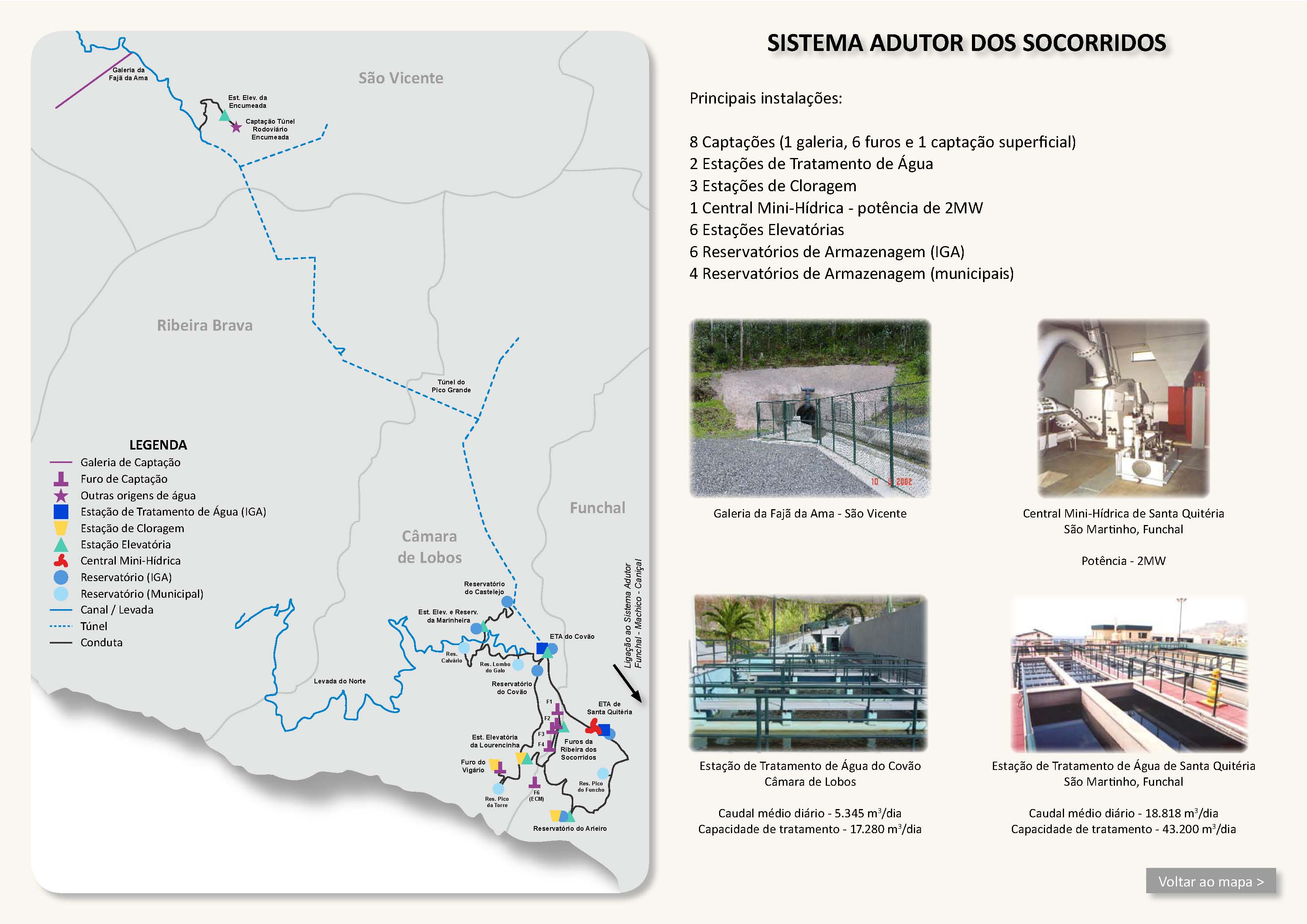
In its southern section the Levada do Norte is now only a shadow of the old levada. The first section, as far as the stream-training structure in the Ribeira do Pico, has been replaced by 2 tunnels. While a large part of the water flows through the Pico Grande tunnel, part of the water is diverted onto the old line in the stream-training structure. In the near future (as of 2016) this part will be replaced by a tunnel 4.9 km long as far as Espigao, to reduce the dangerous and costly maintenance and to avoid losing water. The levada is functionally intact as far as Boa Morte. There all the water is led into reservoirs; the further course to the Ribeira do Campanario is dry. There, through a tunnel supplied with water from the upper balancing reservoir of the Socorridos power system, the levada is brought back into use. Finally, in the area around Nogueira, the landslide is bypassed by the Pau Branco tunnel and the levada is partly run in the "wrong" direction of flow.
Access
Section 1:
-
From the Serra de Agua power station; to get there, by
-
Access to the levada from the VE-4, if the path is not overgrown
-
From the stream-training structure in the Ribeira do Pico (gravel track from Serra de Agua); a large roundabout was built there in 2015, though, so it no longer looks quite the same!
Condition
Section 1: The path is intact as far as the Ribeiro do Poço (maintenance of the stream-training structures); after that the condition is clearly worse, but it is still quite walkable. The tunnels are in places very wet (you have to balance on the little dividing wall), but in places bone dry as well! Moderately difficult, somewhat exposed; sure footing required!
See also Walk 2015
Section 2: Partly piped, danger of rockfall, very dangerous; the path is maintained, but in places extremely exposed and without protection, a brilliant line along the rock face above the Serra de Agua valley, several shorter tunnels. In several places the levada bed has been re-concreted, and at awkward places covered with large plastic pipes. A complete head for heights, sure footing and, if need be, a helmet are necessary!
See also Walk 2015
Section 3: Moderately difficult, exposed in places, but a broader, maintained path; a fair head for heights and sure footing are required
See also Walk 2014
Section 4: Easy, few exposed places,
See also Walk 2014
Section 5: Easy, few exposed places,
From Quinta Grande a branch leads to the Faja das Padres power station (above all in winter, when there is enough water for irrigation)
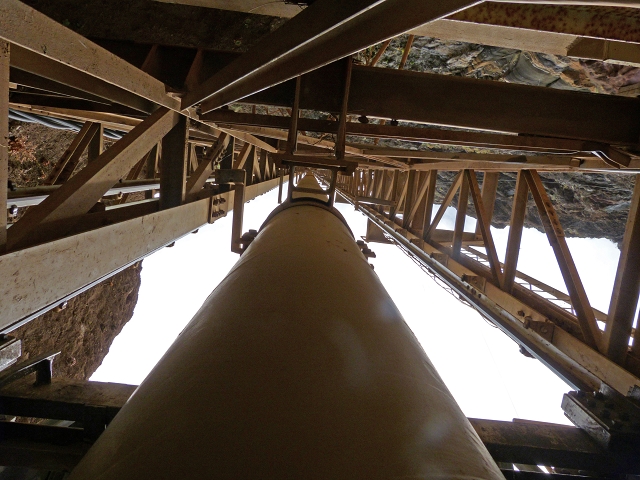
The penstock sits in the frame of the vertical lift!
See also Walk 2015
Section 6: Easy to moderately difficult; in the valley of the Ribeira da Caixa a few exposed places; the masonry passages can be bypassed!
Remarks
For me the southern section of the Levada do Norte is among the best walking Madeira has to offer. For me it was a thrill, pure adrenaline, but also a kind of tribute to those who lost their lives, and to the incredible work behind this construction.