
Daniel’s Levada Directory
Levada do Risco
Also known as Levada do Furado Velho, Levada Velha do Rabacal
Archival documentation — not a current hiking recommendation. Source file on danishome.ch last modified: 16 February 2025
Preliminary note
The original Levada Velha do Rabacal had its Madre in a side stream of the Ribeira Grande and carried water through the Furado Velho as far as Ponta do Pargo. What is often taken for a separate Levada do Furado Velho is therefore part of this levada, and so is the levada known today as the Levada do Risco.
Madrei
Side stream of the Ribeira Grande N 32°45.700 W 17°07.400 ca. 1050 m a.s.l., north-west of the Risco waterfall
Course
From the Madre to the Ribeira Grande the levada runs very exposed, and then in a kind of gallery through the Risco waterfall. This section is barred off by a grille
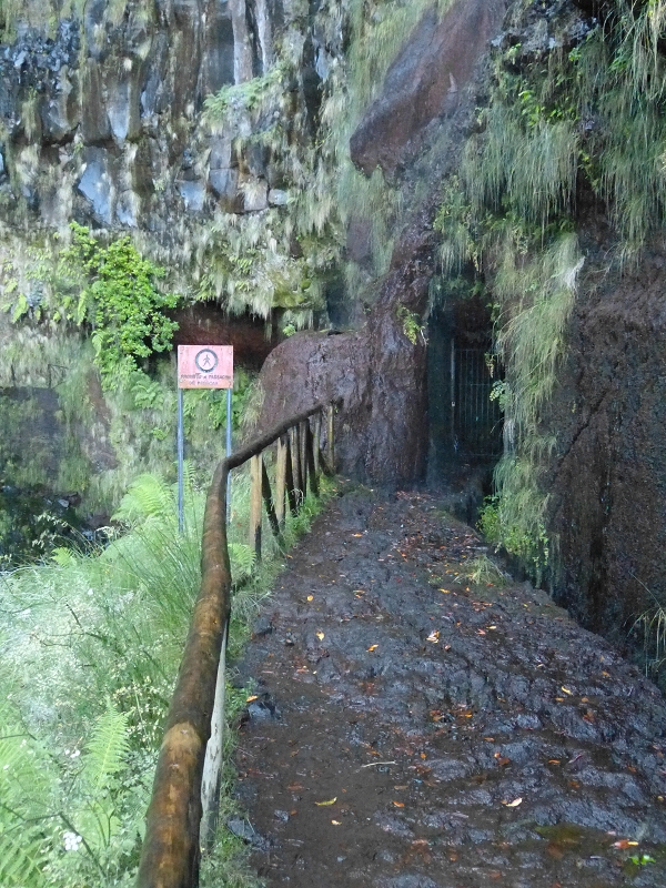
and is not accessible.
A fine viewing platform has been built below the waterfall.
From here it flows beside a wide path. First it passes the way in to the Galeria do Rabacal, which of course is not accessible either.
Here water is taken from inside the mountain through a 560-metre tunnel and led by a pipeline to the Levada Vinte e Cinco Fontes. From here, on the path that accompanies the Furado Novo, and on towards Calheta (see also Walk 2022).
The Levada do Risco passes the ascent from the Levada Vinte e Cinco Fontes and a first path to the Rabacal houses, and the water is held back at the second path to the Rabacal houses.
From here, first the piping and then a steep vertical levada down to the Levada Vinte e Cinco Fontes, which it meets shortly before the Furado Novo.
This section of the Levada Velha, from the waterfall to the outflow towards the Levada Vinte e Cinco Fontes, is generally known as the Levada do Risco.
You can see, though, that the levada went on from the point of the outflow. The continuation had always been relatively easy to walk (Walk 2013); since about 2020, however, the continuation has also been built as a PR and, in my opinion, is well worth recommending. You first pass the third ascent to the Rabacal houses, then come to the bridge over the Ribeira do Alecrim.
Next is the Vereda do Salao, once walked as an insider's tip, to the eastern Ponto, where the ER211 meets the ER110. This path is now also marked as a PR.
On the next lombo there is also a path leading upwards, which was apparently only made or widened in 2022.
On through the typical tree-heath tunnels and along rock faces to the gallery tunnel worth seeing, with its 2 vaults, and on to the second tunnel. Just before the tunnel, the path to the lower Tunel Vieira do Castro branches off!
To the south a path climbs to the ER110 at the western Ponto. At levada level you finally stand before the portal of the monumental Furado Velho.
It is easy to walk for about the first 1/3; after that it becomes extremely muddy and is almost only passable in fishing waders.
The south side of the tunnel is almost completely overgrown. In 2017 we found a way through the thicket with difficulty. Here, though, on the first 300 metres, there are still traces of the old levada and of small retaining walls.
After that the old levada alignment can be followed well on a gravel track. Along it you still pass 2 tunnels through which the levada once flowed; further towards Ponta do Pargo there is still a levada bridge, but no further traces of the old levada.
I suspect that the last part of the Levada dos Marinheiros, from the reservoir onwards, follows the old alignment of the Levada do Risco!
End
Ponta do Pargo ca. 600 m a.s.l.
Function and use
Until 1953: irrigation of the areas around Prazeres, Fajã da Ovelha, Ponta do Pargo and Paúl do Mar
From 1953: a feed to the Calheta I power station, and irrigation and water supply for the south coast via the Levada Nova West and the Levada Nova East
Access
-
Path from the Levada Vinte e Cinco Fontes
-
Rabacal house
-
Stepped ascent at the northern end of the Furado Novo from the Levada Vinte e Cinco Fontes
-
Newly built path from the eastern Ponto; you join it at the entrance from the ER110
-
Well built descent from the ER110 at the western Ponto. The path meets the levada shortly before the Furado Velho (on the east side).
-
With no path, from the ER110 to the southern mouth of the tunnel
Condition
Straightforward; the approach to the southern end of the Furado Velho is overgrown and relatively rough
Historical notes
From 1855 the water was led by the historic Levada do Risco through the Tunel das Estrebarias (Furado Velho da Rabacal) and supplied the lands of the parishes of Prazeres, Fajã da Ovelha, Ponta do Pargo and Paúl do Mar. Today's 'Levada do Risco' and the 'Levada do Furado Velho' together make up the historic Levada do Risco, or Levada Velha do Rabacal!
From 1877 the newly built Furado Novo do Rabacal carried the water of the Levada Vinte e Cinco Fontes to the south side and supplied the area around Calheta, Estreito da Calheta and Arco da Calheta.
In 1953 the water of the Levada do Risco was led entirely, by the vertical levada, to the Levada Vinte e Cinco Fontes. The section known as the 'Levada do Furado Velho' was taken out of use. The water, together with the water of the Levada Vinte e Cinco Fontes, is taken to the Calheta I power station.
The way into the Rabacal area along the historic Levada do Risco was much used by the first tourists on Madeira, which is why the Furado Velho was also made passable for horse-drawn vehicles.
Remarks
For the first time in Madeira's history, in 1835, water was led from the rainy north to the fields on the south side.