
Daniel’s Levada Directory
Levada dos Tornos Nord
Archival documentation — not a current hiking recommendation. Source file on danishome.ch last modified: 25 June 2025
Area
Lombo do Urzal, Ribeira Grande valley, Faja da Nogueira/north-east
Length
21,9 Km.
Construction period
1966
Madrei
Tributary of the Ribeira do Porco N 32°46.500 W 16°59.250 ca. 685 m a.s.l.
Course
The northern branch of the Levada dos Tornos can be divided into 5 sections:
Section 1: From the Madre to the crossing with the PR-2 above Lombo do Urzal, first all 4 side branches and finally the main branch of the Ribeira do Porco are crossed, and water is also led into the levada there. Between the crossing of the 3rd and 4th side branch a path drops away downhill to the Madre of the Levada dos Louros. Wild, untouched country, with a geocache.
Section 2: From the PR-2, first over a side branch of the Ribeira do Porco, increasingly a little exposed but not dangerous, as far as the crossing of a side stream of the Ribeira do Joao Fernandes. Here there is a small feeder levada to admire, cut into the rock. At the next crossing of a lombo, a fine view of Lombo do Urzal and the end of a cable. The levada now turns deep into the valley of the Ribeira do Joao Fernandes. In the valley bottom stands a massive stream-control structure, enlarged considerably again between 2012 and 2015.
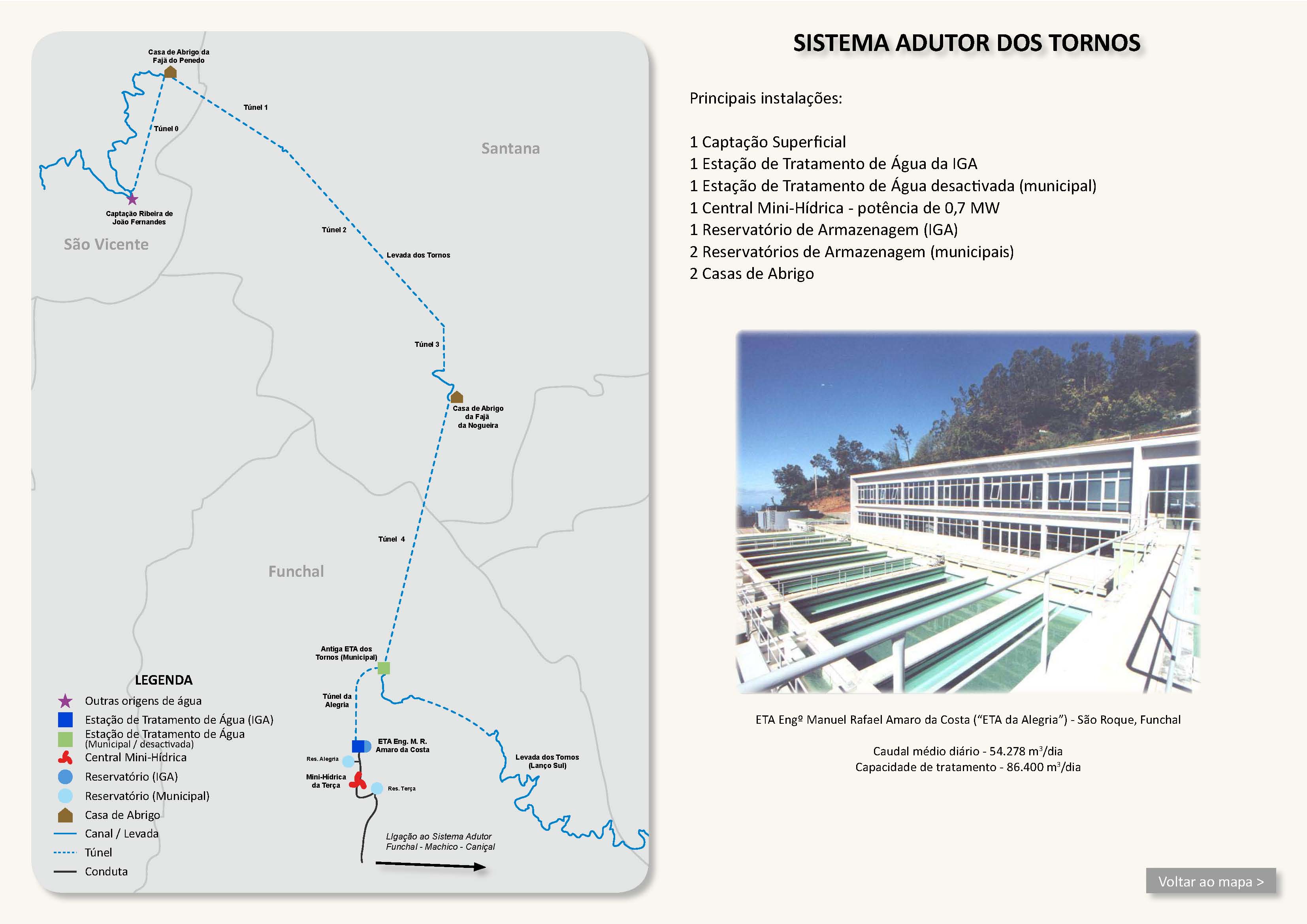
You can leave the levada level by a stairway and, 10 metres higher, see the intake, the treatment plant, the first metres above ground and the entrance to the tunnel of the drinking-water conduit, which goes straight to the levada house above Faja do Penedo.
The levada now winds countless times over lombos and stream crossings, first over side branches and the main branch of the Corrego Caldeira. Here there is a small side levada that can be followed, via a small stairway, a long way into a little side valley. After the next large lombo the slope, levada and all, has slipped. Everything has been perfectly repaired, with a woven fence. Thanks to the landslide the view here is open onto the lower Urzal valley and the onward course of the levada. Then the crossing of the Ribeira do Fojo, and on through a spectacular section cut out of the rock, which again and again opens fine views over the whole Urzal valley. Here too a geocache, which we did not find, though.
The levada then turns east, the ground becomes more open, the path from Chamine/Pico Canario meets the levada from the right, and you pass the end of the drinking-water tunnel, which after a steep section of pipe ends in a small house (I suspect a small generator is also run here). You come to the levada house, which in a privileged position offers a wonderful view of the sea. The levada flows into a treatment plant with a leaf screen; there is a geocache here too; then over a bridge, with the drinking-water pipe running parallel, to the entrance of the first tunnel (2.3 km) to the Ribeira Grande. It is comfortable to walk, in part with a railing, and there is a geocache at the place where the tunnel workers met in the middle during construction.
Section 3: A short levada stretch in the Ribeira Grande (a large stream-control structure): engineering and human work in wild country. Three paths come in here, but all of them suit only sure-footed walkers:
-
Path from the Levada do Rei along the original track by which the workers reached the tunnel site. The gravel track was originally fit for a jeep, but has since slipped in places, and the greatest obstacle along the way is a huge bramble thicket, extremely painful and time-consuming to get through. The first 700 metres are also the approach to the intake of a waterfall in the next side valley to the west (an underground pipe). The path over the last metres is very exposed and slippery. Take care!
-
Ascent 1 to the Levada do Caldeirao Verde and Vale da Lapa, on a narrow path with a somewhat awkward stream crossing
-
Ascent 2 to the start of the Levada do Caldeirao Verde, on a narrow path along and through the gravel bed of the Ribeira Grande and its side branch (poorly marked!)
After the stream-control structure comes the tunnel to the Ribeira Seca (4.5 km), which is closed and can be passed only by boat.
Section 4: A short levada stretch in the Ribeira Seca with a massive stream-control structure, a feeder levada and a geocache; then comes the tunnel to Faja da Nogueira (0.9 km)
Section 5: The water flows into the large basin below the Faja da Nogueira power station. It continues underground under/beside the gravel track as far as the Ribeira das Lajes/do Juncal, with a short section above ground. From here a tunnel as far as the Ribeira Santa Luzia valley (5.5 km) to the old water house, today the Centro Tematico da Agua, and from there on as the Levada dos Tornos Süd
End
Old water house, today the Centro Tematico da Agua, in the Ribeira Santa Luzia valley ca. 600 m a.s.l.
Function and use
Water supply for Funchal, and onward conveyance in the Levada dos Tornos Süd for the water supply of the east coast as far as Santa Cruz. Part of Funchal's drinking-water supply (Tornos system)
Access
Section 1:
-
From Lombo do Urzal towards Curral das Freiras on the PR-2, until the levada is crossed, then against the direction of flow to the Madre, and with the flow towards Faja do Penedo.
-
Ascent from the Madre of the Levada dos Louros
Section 2:
-
Descent on the path from Chamine/Pico Canario, shortly before the levada house
-
Via the levada house above Faja do Penedo: from the ER-101 to Faja do Penedo and Lamaceiros, park here, then on a gravel track to the levada house
Section 3:
-
From the Levada do Rei, shortly before the Madre, heading east (account by the Amigos da Natureza)
-
Descent from the PR 1.1 walking route from Ilha to Pico Ruivo, or from the Levada do Caldeirao Verde (account by the Amigos da Natureza)
-
Descent from the Levada do Caldeirao Verde a little further south, before the climb to the Pico Ruivo tunnel (walked in part by the Caminheiros do Barrete de Orelhas and the Amigos da Natureza).
Section 4:
-
Tunnel from the gravel track to the Faja da Nogueira power station (opposite the entrance to the power station)
-
Unconfirmed descent from the Levadinha Joao de Deus
Section 5:
-
On the gravel track from the ER-103 to Faja da Nogueira.
-
The end at the Centro Tematico da Agua can be reached via the southern part of the Levada dos Tornos.
Condition
-
Section 1: Easy to moderately difficult, a few somewhat exposed places. The levada is regularly kept in good repair.
-
Section 2: Moderately difficult. The path is intact, but there are no railings. The path is very exposed in places and has no tunnels as far as Faja do Penedo. The Paja do Penedo–Chao das Faias tunnel is easy to walk and relatively wide
-
Section 3: The short levada stretch is solidly built in masonry and protected against floods and landslides. A bit windy in places, but very impressive! The Chao das Faias–Ribeira Seca tunnel is closed, and passable only by boat, with no footpath!
-
Section 4: A short concrete passage in beautiful surroundings, a feeder levada from the Ribeira Seca, and the Ribeira Seca–Faja da Nogueira tunnel is easy to walk!
-
Section 5: The levada is not visible. The Faja da Nogueira–Ribeira de Santa Luzia tunnel is not accessible. Staff can drive through it with an amphibious vehicle.
Historical notes
The Levada dos Tornos was built in the second phase of the levada plan of the Comissão Administrativa dos Aproveitamentos Hidráulicos da Madeira, inaugurated in September 1966, and since then has supplied the areas east of Funchal with a constantly high flow of water. The northern branch is really only the feed to the south side, where the southern branch provides drinking water and irrigation.
Remarks
The path from Lombo do Urzal to Faja do Penedo can be made into a circular walk of about 6 hours by descending after the levada house in Faja do Penedo to Lamaceiros and returning on the Levada das Faias. The return, though, has a few tricky spots towards the end (see Walk 2015, or, without the Tornos Madre, Walk 2012)
The approaches to Chao das Faias are very dangerous in places. Depending on whether a walking group has recently cleared the paths with heavy tools, they are often impassable (landslides, bramble thickets). The same is true of the descent from the Levadinha Joao de Deus.